

- Location
- Mount Vernon, 10552
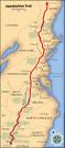
On 3/26 Thurs. I will be starting the longest hike Ive ever been on. I will be starting from AmicalolaFallsState Park. I leave from Penn Station, NY on Amtrac to Atlanta GA where we will be pick up by a shuttle service to the park. The GOAL here is to go from the southern terminus of the AT over the Smokies in VA. I believe the total mileage is 290m ( that's w/o calculating in towns, or mail drop p/u's ) for a time of 4-6 weeks. I have set up 4 mail drops for food along the trail. I start to walk on 3/28.
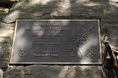
The hike starts from Amicola on the East Ridge Trail at AmicalolaFallsState Park is actually the first mile of a much longer trail, the Southern Terminus Access Trail to SpringerMountain. This blue-blazed trail provides access to the start of the Appalachian Trail. East Ridge Trail climbs to the top of AmicalolaFalls, rising an average of 80 feet for each 500 feet of trail. It is one of a handful of trails which is consider strenuous simply because of the climb. The path climbs a set of steps, and then begins a switchback journey up the steep-sided valley walls of the AmicalolaRiver watershed. The river follows a southerly route, eventually joining the Etowah before creating LakeAllatoona. About halfway up the mountain the pathway curves deep into a steep-sided mountain cove, where it crosses a gully on a wooden bridge. In this area an extremely mature second-growth forest is beginning to take on the appearance of an old-growth forest, a success story for Georgia's state park system.
The trailhead is impossible to miss. It begins as a log-lined walkway leading away from the back of the visitor center at 1790 ft and wastes no time getting down to business. The first 0.5 miles begins the easy to moderate climb to East Ridge Spring. From there, the trail becomes steeper and begins a series of switchbacks and sharper grades before finally turning left onto an old road at 0.7 miles. The left side of the road is a good spot to catch your breath and take in the views of the ridges and valleys. This with a 44.5lbs pack.
I will be posting a photobucket link and some pics I have now and hopefully posting a "hiker log" here to chronicle the hike.
This took 3 months planing meals gear, for 6 weeks while trying to keep the overall weight of my pack down to 40lbs. Weather was another concideration, could be 60-75F during the day and 10-30F at night with possible snow fall in higher elevations....it was a challenge. I also had to arrange for a couple of good MR friends to take care of my reef while I'm away...even that was part of the overall planing. I had to fully automate my set up (if you have any questions on that PM me directly) so that it could run on its own for at least a month.
Well, here are some pics, and the link for photobucket. It wont have pics on it till problably first week april or untill my first log.
http://s714.photobucket.com/albums/ww145/slamajamajama/
Attachments


Last edited: